On Earth Day, we not only think about climate change and natural disasters affecting our world but also recognize technologies that assist in keeping us safe when they occur.
An example of such technology is Google’s environmental crisis notifications.
Each year, countless people experience the devastating effects of natural disasters like floods, wildfires, and earthquakes, leading to the loss of lives and property.
To address this worldwide issue, Google has created environmental crisis notifications, offering quick and precise details to those in affected regions.
These notifications can be found via Google Search and Maps, helping individuals and communities take the needed precautions and make educated choices in times of crisis.
In this article, we look into Google’s environmental crisis notifications, such as flood predictions, mapping wildfires, and detecting earthquakes, and how these innovations help create safer and stronger communities.
Overview Of Google’s Environmental SOS Alerts
Google’s SOS alerts provide people with quick access to authoritative information during emergencies, including summaries of what is happening, relevant news stories, emergency phone numbers, and websites.
Over the years, the SOS alerts have been enhanced to include visual information about natural disasters.
A new navigation warning system on Google Maps also allows people to anticipate and understand the disaster’s trajectory.
For example, in the days leading up to a hurricane, people near the impacted area will see a crisis notification card on Google Maps that directs them to a hurricane forecast cone.
The notification shows the predicted trajectory of the storm and the timing of its impact on specific areas.
Similarly, the crisis card will display an earthquake shakemap after an earthquake.
A shakemap shows a visualization of the earthquake’s epicenter, magnitude, and intensity of shaking in surrounding areas, helping users assess the reach and impact of the earthquake.
People in India, where over 20 percent of global flood-related fatalities occur, can access flood forecasts that show the likelihood and severity of flooding in different areas.
Google has alerts for the following types of environmental crises:
- Floods
- Wildfires
- Earthquakes
- Hurricanes
- Extreme Heat
Here’s more information about each type of alert.
Floods
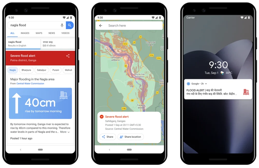
Floods are among the most frequent and damaging natural disasters, significantly affecting communities and economies around the globe.
To lessen the impact of floods, Google has created real-time flood prediction models, collaborating with local governments.
These models estimate when and where flooding will happen and how severe it will be, enabling people to be better prepared for possible floods.
Google’s flood prediction tech is based on physics-oriented modeling and machine learning.
It employs data from satellite images, measurement gauges, and elevation maps to produce precise forecasts and flood models, which determine the regions that will be submerged and the water’s depth.
In addition to forecasting, Google offers interactive maps allowing people to see their location relative to a predicted flood quickly.
Google.org, the philanthropic arm of Google, is working to support the International Federation of Red Cross and Red Crescent Societies in building local networks to deliver flood alert information to those who may not have access to internet-connected devices.
Wildfires
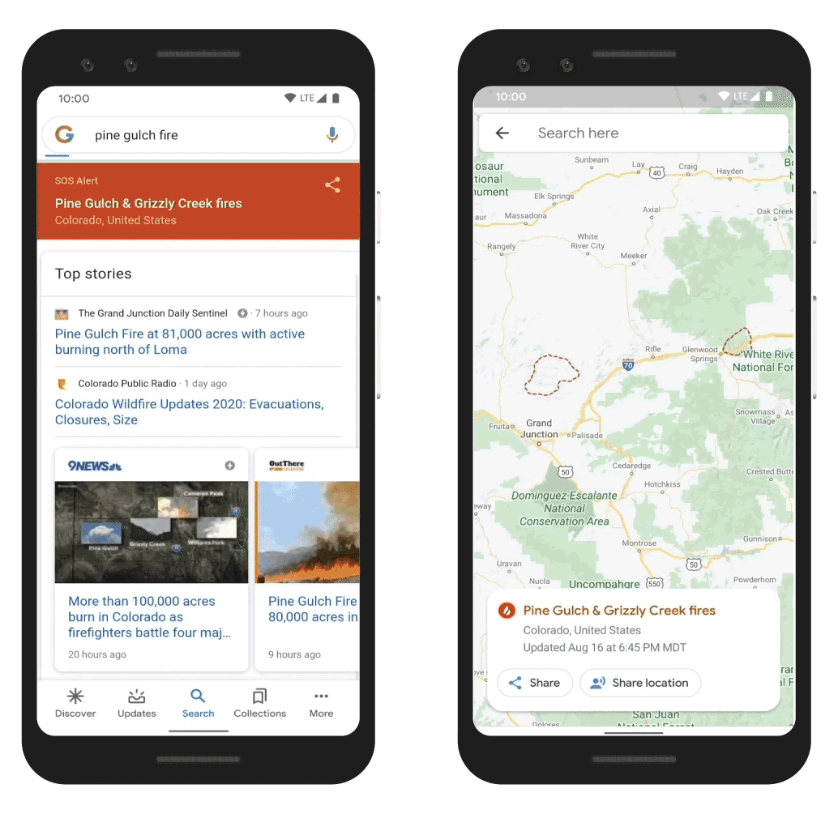 Screenshot from: blog.google/products/search/mapping-wildfires-with-satellite-data/, April 2023.
Wildfires pose a significant threat to communities, and early detection is critical in minimizing damage.
Using data from NOAA’s satellites and the computing power of Google Earth Engine, Google can detect active wildfires and produce approximate boundaries on Google Search and Maps.
Google’s wildfire boundary maps, built using infrared technology and optical imagery, are accompanied by safety information from local authorities.
This information includes details on shelters and evacuation procedures, which are crucial for those affected by wildfires.
Earthquakes
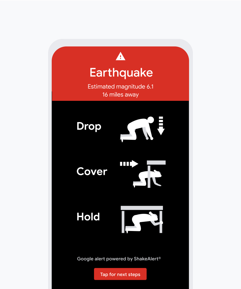 Screenshot from: crisisresponse.google/forecasting-and-alerts/, April 2023.
Earthquakes are particularly challenging due to their unexpected and hard-to-predict nature.
To tackle this issue, Google has teamed up with ShakeAlert to deliver earthquake notifications straight to Android devices in California, Washington, and Oregon.
ShakeAlert, created by top seismologists, uses data from over 700 seismometers to identify and give early warnings for earthquakes.
Understanding that traditional seismometers aren’t accessible in many parts of the world, Google devised the Android Earthquake Alerts System, turning Android phones into mini seismometers and creating the largest earthquake detection network globally.
When an earthquake is identified, the system notifies Android users in impacted areas, enabling them to take necessary precautions and find safety.
Hurricanes
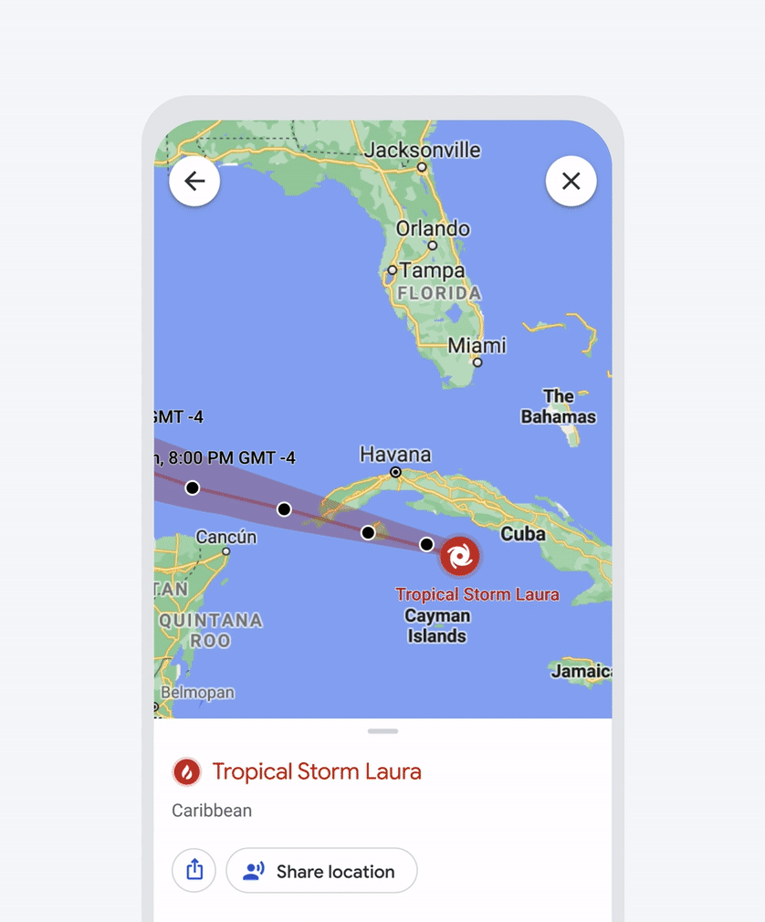 Screenshot from: crisisresponse.google/forecasting-and-alerts/, April 2023.
In the days leading up to a hurricane, Google Search and Maps display detailed forecast cones from authoritative sources. These cones show the storm’s predicted trajectory, helping users understand the hurricane’s potential impact.
Google Maps also provides prominent alerts if a user’s route may be affected by storm activity, and road conditions are kept up to date to ensure safe navigation during such events.
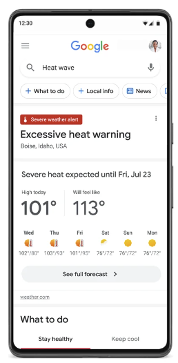
Extreme Heat
 Screenshot from: blog.google/outreach-initiatives/sustainability/extreme-heat-support/, April 2023.
To help communities adapt to rising temperatures, Google has launched initiatives focused on extreme heat alerts and AI-powered tools for urban heat mitigation.
When people search for information on extreme heat, Google Search will display new extreme heat alerts that provide details on when a heatwave is predicted to start and end.
Google’s alerts also include tips for staying cool and related health concerns to be aware of.
This information is prominently displayed in Search results, and the alerts are developed in collaboration with the Global Heat Health Information Network (GHHIN).
Conclusion
As the world faces increasing environmental crises, technology like Google’s environmental crisis alerts is vital in keeping people informed and safe.
This Earth Day, we recognize the importance of using technology to limit the impact of natural disasters.
By giving communities access to up-to-date information and resources for disaster readiness, Google is helping to reduce the consequences of harsh weather conditions.
Featured Image: 3d_kot/Shutterstock
if( typeof sopp !== "undefined" && sopp === 'yes' ){ fbq('dataProcessingOptions', ['LDU'], 1, 1000); }else{ fbq('dataProcessingOptions', []); }
fbq('init', '1321385257908563');
fbq('track', 'PageView');
fbq('trackSingle', '1321385257908563', 'ViewContent', { content_name: 'googles-environmental-crisis-alerts', content_category: 'local-search' }); } });
